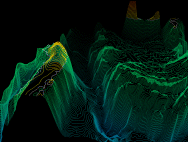
The "oceantopo" file is an extension of the database used to produce the current standard benchmark called "seafloor." Like "seafloor," the new file is a 3D wireframe model of the ocean floor contour lines and some islands above. The data is typical of applications that do mapping of seafloor terrain for exploration purposes. Color is used to depict elevations, with deep blue representing the deepest part of the ocean and red the highest areas above sea level. The sea-level boundary is depicted as a white contour line. While the model is being rotated and translated, the depth-cue mapping is changed several times to make the foreground data more visible. The data set comprises 991 contour lines on 211 depth levels. Each contour line is represented as anti-aliased, depth-cued 3D polylines. The file contains a total of 600 frames with an average of 459,809 vectors per frame.