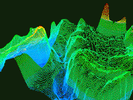
The "seafloor" file is a 3D wireframe model representing the contour lines of the ocean floor and the islands above. This data is typical of applications that do mapping of seafloor terrain for exploration purposes. Color is used to depict elevations, with deep blue representing the deepest part of the ocean, and red the highest areas above sea level. The sea-level boundary is depicted as a white contour line. While the file is being run, the terrain data is rotated 360 degrees, followed by additional translations and rotations. The data set comprises 984 contour lines on 211 depth levels. Each contour line is represented as solid 3D polylines. There are 540 total frames with an average of 229,682 vectors per frame.